Purpose of the flight and payload description
Is a modified version of the LPMA instrument (Limb Profile Monitor of the Atmosphere originally created to made Earth's limb measurements) used to observe the Earth's atmospheric emission at nadir, to determine the vertical profiles of various atmospheric gases such as H2O, CO2, CO, O3, N2O, & CH4 from high resolution atmospheric spectra. Their major goal is the preparation of the so called IASI mission, which is a satellite instrument dedicated primarily to operational meteorology, hence it is also known as IASI-balloon.
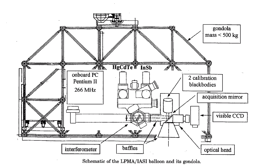
The instrument is composed by a BOMEM DA2 infrared Fourier transform spectrometer coupled with a movable mirror. An optical head with an aquisition mirror looks down and made the nadir observation while two references blackbodies one warm and the other cool are used for reference purposes. A CCD camera is used to image in the visible the atmosphere observed by the spectrometer and to make corrections in the instrument attitude commanding the aquisition mirror. The instrument is installed in the same gondola developed by the CNRS for the LPMA instrument, wich have an azimuth control system to compensate the balloon motion. An onboard PC computer controls the instruments during the flights, recording the interferograms and ensuring the telecommand and telemtry link with the ground station.
Details of the balloon flight
Balloon launched on: 8/5/2002 at 18:05
Launch site: European Space Range, Kiruna, Sweden
Balloon launched by: Centre National d'Etudes Spatiales (CNES)
Balloon manufacturer/size/composition: Zero Pressure Balloon
End of flight (L for landing time, W for last contact, otherwise termination time): 8/5/2002 at 22:17
Balloon flight duration (F: time at float only, otherwise total flight time in d:days / h:hours or m:minutes - ): 4 h 20 m
Landing site: 200 kms southwest from Kiruna, Sweden
Campaign: ENVISAT
The balloon was launched at 18:05 utc on August 5, 2002 using the auxiliary balloon method.
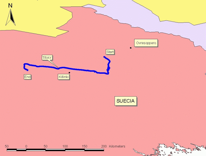
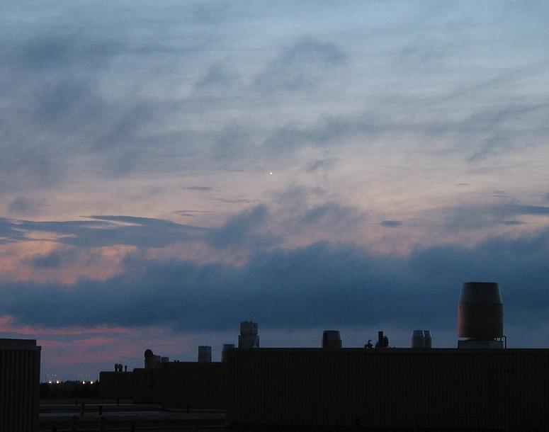
After and ascent phase of near two hours, the balloon reached float altitude at 31 km at 19:55 utc and started an west path with a controlled descent to 26 km as can be seen in the map at left (click to enlarge). At 22:17 utc the separation command was transmited and the payload landed 200 km southwest of Kiruna. During the float phase, due to the flight was done during the boreal summer the balloon shinning under the midnight sun was clearly visible from Oulu, a Finnish city located 300 km from Kiruna. The picture at right was obtained by the amateur astronomer Tomi Leppikangas.
External references
- LPMA project website Laboratoire de Physique Moléculaire pour l'Atmosph&eagrave;re et l'Astrophysique (via Archive.Org)
- ENVISAT VALIDATION 1 Measurements made by balloon SSC Press release
- ENVISAT Validation Results Obtained with LPMA and IASI-Balloon FTIR 2nd Workshop on the Atmospheric Chemistry Validation of ENVISAT, 2004
- List of balloons launched from ESRANGE SSC Space website (via Archive.Org)
- Mesure de l'ozone troposphérique à partir d'observations satellitaires dans le domaine de l'infrarouge Sol&eagrave;ne Turquety - PhD Thesis, University Paris 6 - Pierre et Marie Curie
- Overview of SCIAMACHY validation: 20022004 Atmos. Chem. Phys., 6, 127-148, 2006
- Results obtained during recent flights of the LPMAA balloon experiment and contribution to the ENVISAT validation 17th ESA Symposium on European Rocket and Balloon Programmes and Related Research, 30 May - 2 June 2005, Sandefjord, Norway
- The Validation of the Envisat Chemistry Instruments by Use of Stratospheric Balloons and Aircraft ENVISAT Validation Workshop (ESA SP-531). 9-13 December, Frascati, Italy
Images of the mission
If you consider this website interesting or useful, you can help me to keep it up and running with a small donation to cover the operational costs. Just the equivalent of the price of a cup of coffee helps a lot.
