
The archipelago of Svalbard is the northernmost territory of Europe and is located between 74 and 81 degrees north latitude. This consists of a group of islands, among which the biggest is Spitsbergen along with Nordaustlandet, Kong Karls Land, Prins Karls Forland, Barentsøya, Edgeøya, Hopen, Bjørnøya and a myriad of small islands. The total area of the archipelago is 62,700 km2, although two thirds of its surface is covered by glaciers. The distance to the North Pole is 1000 kms.
Svalbard is part of the Kingdom of Norway -the country has sovereignty over the territory- and the majority of the population is of this origin, however there are important settlements of Russians and Ukrainians inmigrants.

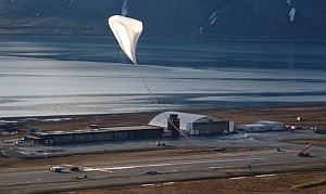
Its proximity to the pole have given the archipelago a special attractive for scientists, so since the late 70's it was used on several occasions to perform launches of meteorological research rockets and stratospheric balloons. The image you see on the left is just one of those campaigns, developed in 1992 by the French space agency CNES from Ny Alesund, settlement located on the west coast of the Spitzbergen island. Also the Japanese space agency ISAS / JAXA made some experiences balloon launches from there in the same decade as you can see at right.
The main facilities for launching rockets on the island are operated by the Andoya Space Range (ASR). As there is no dedicated facility for launching stratospheric balloons, the missions performed have been limited to small balloons launched using minimal mobile infrastructure. However, in 2002 emerged a project propelled by the Italian Space Agency (ASI) -which operated until its closure in 2010 the permanent balloon launch base of Trapani, in Sicilia- with their Norwegian colleagues to establish the infrastructure necessary to make long duration scientific balloon flights around the pole, emulating the program that NASA performs every year with stratospheric balloons in Antarctica.
The new launch facilities in Svalbard would be denominated "Nobile / Amundsen Stratospheric Balloon Centre" as a tribute to the team composed of Norwegian polar explorer Roald Amundsen and his Italian partner, explorer, pilot and engineer Umberto Nobile. Both departed from Svalbard aboard the dirigible "Norge" and after overcoming bad weather and mechanical problems with the vehicle they reached the North Pole on May 11, 1926, ending five days later its journey in Point Barrow, Alaska.
First studies
In the context of this project, in 2002 studies were conducted in various parts of the archipelago. At first, the Ny-Alesund settlement was under consideration as a possible site for the launch base, but this first option was finally discarded. In March the following year it was conducted a new survey this time with positive results for Longyearbyen. This location have all the necessary infrastructure (including an airport) to meet the needs of a balloon launch campaign.
After selecting the site, the first step was to carry out a statistical survey of the surface winds of the last 10 years, based on data obtained from the local weather station. From this study was clear that existed in the summer a period of between 13 and 22 days of duration with winds calm and stable enough to allow the launching of balloons of great volume. The next step for the project was taken in June, when the first flights were performed, using small balloons measuring 3000 m3. In this flights was obtained very valuable information on the wind circulation patterns within the polar vortex. As launch site was used the runway of the local airport. This was located about 3 km west of the village on a small plateau on the edge of Adventfjorden. The operations were conducted by staff from ISTAR an US balloon launch firm under contract with the Italian space agency.
The experiments were repeated in the following years including onboard small scientific payloads in many of them. During the last series conducted in 2006 a historical landmark was achieved when for the first time a stratospheric balloon performed a complete circumnavigation of the North Pole.
A project on hold
Initial plans envisaged the completion of the first flights of a more complex scientific payloads by 2008. Among the possible candidates to be taken on this maiden flight were two instruments developed by Italian universities, BaR-SPort a microwave polarimeter, and a submillimeter telescope denominated Olimpo. Both instruments would study the cosmic microwave background. However, almost eight years after its inception, the project still does not materialize.
All balloons launched from Svalbard have been flown still using the Longyearbyen airport facilities, as no dedicated facilities have been built for this purpose elsewhere on the island. The reason this could be the economic crisis that affected the European Union during the decade -which led for instance to the closure and dismantling of the Italian balloon base of Trapani-Milo in Sicily- that could have changed the initial plans for investment in a dedicated infrastructure.
Aditionally, the missions performed so far have been limited to flights from Svalbard to Greenland or the north of Canada, but not completing a full circumnavigation to the pole which is the main interest of the scientific community. According to data published by the Italian space agency this is due to the refusal of Russia to allow the overflight of its territory.
Table of balloons launched from Ny Alesund
| Date | Hour | Flight Duration | Experiment | Payload landing place or cause of the failure |
|---|---|---|---|---|
| 8/13/1979 | 16:25 | 17 d | WATCH (Wide Angle Telescope for Cosmic Hard X-Rays) | --- No Data --- |
| 7/1/1992 | --- | VALVE TEST ON MIR BALLOON | --- No Data --- | |
| 7/3/1992 | 30 d | VALVE TEST ON MIR BALLOON | --- No Data --- | |
| 7/13/1992 | --- | VALVE TEST ON MIR BALLOON | --- No Data --- | |
| 7/23/1994 | 10:39 utc | OPTICAL OZONE SENSOR | --- No Data --- | |
| 7/27/1994 | 9:56 utc | OPTICAL OZONE SENSOR | --- No Data --- | |
| 8/19/1997 | 2 h | OPTICAL OZONE SENSOR | --- No Data --- | |
| 8/23/1998 | --- | OPTICAL OZONE SENSOR | --- No Data --- | |
| 8/29/1998 | 3 h | OPTICAL OZONE SENSOR | --- No Data --- | |
| 7/11/2001 | 3 h | OPTICAL OZONE SENSOR | --- No Data --- | |
| 7/12/2001 | 3 h | OPTICAL OZONE SENSOR | --- No Data --- | |
| 1/7/2011 | 19:00 utc | 2 h | POP # 1 (Polar Observation Platform) | In a Glacier at 79º 03' N 12º 22' E. Svalbard Archipelago |
| 1/9/2011 | 12:30 utc | 5 d 12 h | POP # 2 (Polar Observation Platform) | In the Kara Sea, offshore Tamir peninsula, Russian Federation |
| 1/17/2012 | 18:55 utc | 2 h | POP # 1 (Polar Observation Platform) | In a Glacier at 79º 03' N 12º 22' E. Svalbard Archipelago |
| 1/19/2012 | 19:26 utc | 28 h | POP # 2 (Polar Observation Platform) | Gotland Island, Baltic Sea |
Table of balloons launched from Longyearbyen airport
| Date | Hour | Flight Duration | Experiment | Payload landing place or cause of the failure |
|---|---|---|---|---|
| 6/15/2003 | 16:36 | 1 d | PATHFINDER - 1 | In the Greenland Sea. |
| 6/16/2003 | 19:37 | 1 d | PATHFINDER - 2 | In the Greenland Sea. |
| 6/19/2003 | 19:30 | 18 h | PATHFINDER - 3 | 60 kms away from launch site |
| 7/9/2003 | 10:41 | 5 h | PATHFINDER - 4 | 15 kms away from launch site |
| 7/12/2003 | 10:50 | 1 h | PATHFINDER - 5 | In the sea near launch site |
| 7/12/2003 | 15:50 | 5 d | PATHFINDER - 6 | --- No Data --- |
| 7/24/2004 | 21:33 | 38 d | Trailblazer + PEGASO (Polar Explorer for Geomagnetics And other Scientific Observations) | North of russian federation at coordinates 68º 34' N 164º 19' West |
| 6/29/2005 | 3:12 local | 25 d | Trailblazer + PEGASO (Polar Explorer for Geomagnetics And other Scientific Observations) | Over international water (pack-ice) at 11:15 utc at 80º 46,743' N - 107º 18.276' E |
| 7/6/2005 | 23:00 local | 14 d | Trailblazer + PEGASO (Polar Explorer for Geomagnetics And other Scientific Observations) | Over international water (pack-ice) at 17:57 utc at 72º 51.969' N - 176º 47.698' W |
| 6/14/2006 | 14:56 | 17 d | Trailblazer + PEGASO (Polar Explorer for Geomagnetics And other Scientific Observations) | At coordinates 81º 28' N - 5º 24' W in the N part of Greenland. |
| 6/21/2008 | 6:05 | 4 d | DUSTER (Dust in the Upper Stratosphere Tracking Experiment and Return) | Near the Thule Air Base, Greenland |
| 7/1/2009 | 00:08 utc | 3 d | SORA (Sounding Radar) | In Baffin Island, Canada |
| 6/17/2010 | 20:30 utc | 72 h 33 m | SURECA (Summer Recovery Campaign) + BIT (Bidirectional Iridium Telemetry) | On Ellesmere Island, Canada |
| 8/17/2014 | 8 d | OLIMPO PROJECT SYSTEMS TEST | --- No Data --- | |
| 12/17/2017 | 17:58 utc | 24 h | TECHNOLOGICAL FLIGHT | Payload impacted at coordinates 65º 57', 18º 37', Sweden |
| 7/3/2018 | --- | OLIMPO | Balloon failure at launch | |
| 7/14/2018 | 7:05 utc | 4 d 20 h | OLIMPO | In Ellesmere Island, Nunavut Territory, Canada |
If you consider this website interesting or useful, you can help me to keep it up and running with a small donation to cover the operational costs. Just the equivalent of the price of a cup of coffee helps a lot.
