 HIBISCUS Campaign (2004)
HIBISCUS was an European funded scientific campaign devoted to study the chemical species involved in stratospheric ozone depletion at global-scale in the tropics.
As the compounds are transported vertically from surface level to the tropopause by deep convection, the main goal of the campaign was to study a number of dynamical, microphysical, radiative and chemical aspects of the Upper Troposphere and Lower Stratosphere (UT/LS) related to deep convection in the region.
It was part of the Tropical phase of the VINTERSOL effort so it's costs were supported by the European Commission and partners national research agencies as a shared project.
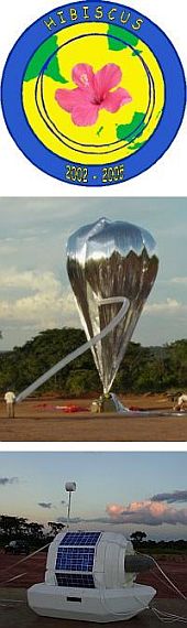
It was carried out from the balloon launch facilities of the Instituto de Pesquisas Meteorologicas (IPMET) of the Universidade Estadual de Sao Paulo in Brazil in 2004.
The campaign, however, started three years before, when was carried out a first technical campaign in 2001 and a series of balloon launches in 2003 englobed in the ENVISAT Pre-HIBISCUS campaign dedicated to the validation of ENVISAT satellite data and the testing of new instrumentation.
During both efforts were used open stratospheric balloons as well Infrared Montgolfier (MIR) balloons both provided and operated by the balloon group of the French Space Agency (CNES). The MIR balloons -a special kind developed by French scientists back in the 70's- were specially suited to perform circumglobal flights along the tropics.
The HIBISCUS campaign started in January 2004 and lasted until March during the southerm hemisphere summer.
The experimental approach, based on successful techniques developed for the Arctic European campaigns in the 90's, was to combine in situ measurements by a variety of instruments flown on small balloons for few hours in Brazil during the summer convective season and on MIR balloons for several weeks around the world in the tropics, with support of ground-based measurements in Brazil, simultaneous observations at La Réunion and state of the art transport, microphysical, radiative and chemical modelling.
In all 31 flights were made, including several long duration missions that circled the globe following the same latitude of Bauru.
List of balloons launched during HIBISCUS campaign
| Launch base | Date | Flight Duration | Experiment | Payload landing place or cause of the failure |
|---|---|---|---|---|
 Baurú GLB (SP) Baurú GLB (SP) | 2/23/2003 | 8 d | MIR (Montgolfier Infra-Rouge) | Payload lost in the ocean. |
| Baurú GLB (SP) | 1/31/2004 | 2 h 10 m | SAOZ (Systeme d'Analyse par Observation Zenithale) + SAOZ-BrO + LABS backscatter diode laser | In a sugar cane field in Paraguaçu Paulista located 100 km from launch site. |
| Baurú GLB (SP) | 2/4/2004 | --- | SAOZ (Systeme d'Analyse par Observation Zenithale) + IR RADIOMETER | Somewhere near the NW Australian coast. |
| Baurú GLB (SP) | 2/5/2004 | --- | SAOZ + SAOZ-BrO + DIRAC | 80 km W from launch site. |
| Baurú GLB (SP) | 2/6/2004 | ~ 13 d | RUMBA + TURBULENCE | On the Pacific Ocean (22.34º S - 149.65º W) |
| Baurú GLB (SP) | 2/10/2004 | --- | BACKSCATTER SONDE | --- No Data --- |
| Baurú GLB (SP) | 2/12/2004 | --- | BACKSCATTER SONDE | --- No Data --- |
| Baurú GLB (SP) | 2/12/2004 | 53 d | RUMBA + TURBULENCE | 60 kms W of the town of Franklin, Queensland, Australia |
| Baurú GLB (SP) | 2/12/2004 | 1 d | RUMBA + O3/H2O | On Brazil territory (21.09º S - 50.97º W) |
| Baurú GLB (SP) | 2/13/2004 | 4 h 25 m | DESCARTES + µLIDAR + µDIRAC + O3 SSS + H2O SAW + µSDLA | 90 km N of Bauru, Brazil |
| Baurú GLB (SP) | 2/13/2004 | --- | NILU CUBE | 80 km N of Bauru, Sao Paulo, Brazil |
| Baurú GLB (SP) | 2/13/2004 | --- | BACKSCATTER SONDE | --- No Data --- |
| Baurú GLB (SP) | 2/16/2004 | --- | BACKSCATTER SONDE | --- No Data --- |
| Baurú GLB (SP) | 2/16/2004 | 7 h 21 m | DESCARTES + LABS + AIRS + µDIRAC + O3 SSS + H2O SAW + TDLAS | Near the Parana state border, Brazil |
| Baurú GLB (SP) | 2/17/2004 | --- | BACKSCATTER SONDE | --- No Data --- |
| Baurú GLB (SP) | 2/19/2004 | --- | BACKSCATTER SONDE | --- No Data --- |
| Baurú GLB (SP) | 2/21/2004 | --- | BACKSCATTER SONDE | --- No Data --- |
| Baurú GLB (SP) | 2/21/2004 | --- | BACKSCATTER SONDE | --- No Data --- |
| Baurú GLB (SP) | 2/23/2004 | --- | BACKSCATTER SONDE | --- No Data --- |
| Baurú GLB (SP) | 2/24/2004 | --- | BACKSCATTER SONDE | --- No Data --- |
| Baurú GLB (SP) | 2/24/2004 | ~ 4 h | µDIRAC + µLIDAR + µSDLA + O3 SSS + H2O SAW + AIRS | 150 kms. SE of Bauru, Brazil |
| Baurú GLB (SP) | 2/25/2004 | --- | NILU CUBE | 40 kms. S of Baurú. |
| Baurú GLB (SP) | 2/26/2004 | --- | DESCARTES + µDIRAC + LABS + O3 SSS + H2O SAW + TDLAS | --- No Data --- |
| Baurú GLB (SP) | 2/26/2004 | 39 d | SAOZ (Systeme d'Analyse par Observation Zenithale) + IR RADIOMETER + LIGHTING/BLUE JET SENSOR | On the Pacific Ocean (9.16º S - 210º W) |
| Baurú GLB (SP) | 2/29/2004 | 80 d | TECHNOLOGICAL FLIGHT | In Madagascar Island |
| Baurú GLB (SP) | 3/3/2004 | 30 m | µLIDAR | A few kilometers NE of Baurú |
| Baurú GLB (SP) | 3/6/2004 | 39 d | OZONE AND WATER VAPOUR SENSORS | In Antarctica (74º S - 88º E) |
| Baurú GLB (SP) | 3/7/2004 | 56 d | TURBULENCE SENSOR | On the Indian Ocean south (56.4º S - 56.2º E) |
| Baurú GLB (SP) | 3/9/2004 | 27 d | OZONE AND WATER VAPOUR SENSORS | In Antarctica (77º S - 127º W) |
| Baurú GLB (SP) | 3/10/2004 | 9 d | µLIDAR | In the Western Pacific half way between New-Caledonia and Fiji |
| Baurú GLB (SP) | 3/11/2004 | 37 d | TECHNOLOGICAL FLIGHT | In the Antarctic Sea (58º S - 151º W) |
Related Entries
External Links
HIBISCUS campaign website - at the Service d'aéronomie server
About StratoCat
Some Statistics
+ 20 articles from different contributors
+ 15914 balloon launch records already published
+ 16008 balloon launch records in the full database
StratoCat is a non-profit, educational and informative website created, developed and programmed by Luis E. Pacheco. It is based on an idea first conceived by the author in 2001 and is online since September 17th, 2005.
This website is an independent initiative, and thus is not endorsed, supported or have any relationship with any governmental or private agency or company in the balloon field.
Page generated on 22-Feb-2026 - 12:09:37pm  © StratoCat 2005~2026 - All Rights Reserved.