Purpose of the flight and payload description
This flight was part of the developmental work carried out in the context of a program started in 1957 by the Balloon Research Branch of the Research Instrumentation Laboratory at the Air Force Cambridge Research Laboratories (AFCRL) to develope a fully-operational superpressure vehicle for a wide variety of applications. Additionaly the flight served to a secondary study carried out by the AFCRL in the summer of 1962 of the spatial and temporal characteristics of minimum-wind fields in the lower stratosphere. The balloon trajectories served to illustrate the use of minimum-wind phenomena and helped to delineate some of the characteristics of the wind fields examined.
THE BALLOON
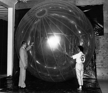
The superpressure balloon was formed by a closed envelope that maintained a constant altitude without expenditure of ballast. Key to the design of the balloon was that its internal pressure must exceed that of the surrounding air. In the image at left we can see one of such balloons fully inflated during an indoor test. The balloon was spherically shaped with a diameter of 34 ft. Construction was made by laminating two extremely thin Mylar films 1.5 microns thick. It carried a payload of 40 lb. and was designed to float at an altitude of 70,000 ft for several days. The balloon was fabricated by G.T. Schjeldahl Co.
CONTEXT
Development of the superpressure balloons capable of flights lasting in excess of 30 days, as well as advances in the technology of high-altitude tethered balloons in the decade of 1960, generated considerable interest in the existence of parcels of air with relatively stable layers of minimum winds in the lower stratosphere, also known as minimum or zero wind fields. Minimum-wind fields are relevant to many high-altitude constant-level balloon applications: to free-floating balloons, whenever it is desirable to obtain maximum flight duration with minimum horizontal movement from a fixed geographic location; and to tethered-balloon systems, when the dynamic pressure upon the balloon should be minimum.
The study of which was part the present flight was limited to consideration of altitudes from 49,000 ft to 100,000 ft over the North American continent during the five months from 1 May 1962 through 30 September 1962. The data core of the study was information obtained daily at 12:00 GMT of upper-level wind speeds for each kilometer of altitude between 15 km and 29 km, taken at the meteorological stations across United States, Canada, Alaska, Mexico and the Atlantic ocean. The stations were chosen so as to most nearly obtain a series of observations along latitudes equidistantly spaced, from lat. 20º N to 65º N. With this data were obtained meridional cross sections of wind speeds averaged over either 10 or 11 day periods as a function of latitude and altitude that later were used to infer the general state of the minimum-wind layer in function of the month and the distribution and general characteristics of the minimum-wind level.
Details of the balloon flight

Balloon launched on: 5/31/1962 at 9:15 utc
Launch site: Kindley Air Force Base, Bermuda Islands
Balloon launched by: Air Force Cambridge Research Laboratories (AFCRL)
Balloon manufacturer/size/composition: Super Pressure Balloon Mylar Laminate - 34 ft diameter
Flight identification number: P-27
End of flight (L for landing time, W for last contact, otherwise termination time): 6/19/1962 at 12:00
Balloon flight duration (F: time at float only, otherwise total flight time in d:days / h:hours or m:minutes - ): 19 d
Landing site: 200 miles SE of Iwo Jima island, Pacific Ocean
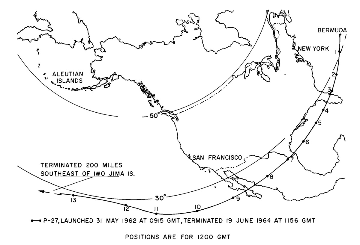
Flight P-27 was launched from Kindley AFB in Bermuda on May 31, 1962 at 09:15 GMT. Its floating altitude was 66,500 ft and it flew for 19 days before it was terminated by radio command from the AFCRL Balloon Launch Site, Chico, Calif. Its altitude was such that it never was located in the minimum-wind layer. It was under persistent easterly flow throughout its entire flight and increased in speed from about 10 knots at the beginning of its flight to speeds close to 30 knots at the time when it was terminated 200 miles southeast of Iwo Jima Island.
External references
- Air force research balloon completes 19-Day flight Reading Eagle - 20 Jun 1962 - Pag 68
- High altitude minimum wind fields and balloon aplications Air Force Cambridge Research Laboratory, Oct. 1964
- The constancy of the winds in the lower stratosphere and constant-level balloon flight planning Air Force Surveys in Geophysics Nº 166, June 1965
262If you consider this website interesting or useful, you can help me to keep it up and running with a small donation to cover the operational costs. Just the equivalent of the price of a cup of coffee helps a lot.


