In 1964, the Centre National d'Etudes Spatiales (CNES) from France, as part of his recently born space program started to build a satellite tracking station near the town of Hammerskraal, some 45 km north of Pretoria, in Gauteng province. The station was located in a very isolated field of 52 hectares on a farm called Paardefontein (horse fountain in afrikaans language).
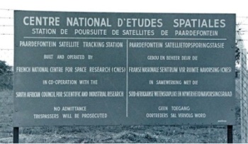
The station was operated by the CNES with support from the southafrican Council for Scientific and Industrial Research (CSIR) and consisted mainly in a series of buildings and antennas to perform the tracking tasks.
The first personnel and technicians arrived the site in April 1965 to put to work the already installed DIANE system devoted to track satellites (then only the Americans ones) by mean of a interpherometer. April 29 marks the beginning of the operations at Paardefontein when the DIANE system receives the first analogue message sent by the Beacon Explorer C.
During the rest of the year the growing of the station continued steadily: by July a second team arrived so now 15 people are working there, in September was installed the IRIS equipment for telemetry and telecommand, and finally the formal inauguration arrives on November 12, 1965 when were received the signals coming from the A-1 satellite. Nevertheless, an historical landmark was achieved in December when the antennas of the station picked up the first technological measurements of the French satellite FR-1 merely 40 minutes after it was launched from California.
The balloon era
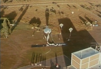
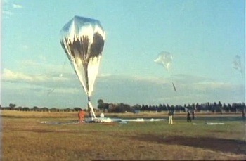
In 1968, the station served as base to launch balloons in the framework of the pre-EOLE campaign to test the capabilities and behavior of the superpressure balloons to be used later in the EOLE campaign (Argentina 1971). This also was the first time that Paardefontein was used to perform balloon launches, thus forcing the agency to build a dedicated building with enough room to prepare the payloads and inflate the balloons. Also were added small offices and a place to install the receiving equipment (two Racall receivers) destined to listen the signals sent by the balloons.
The first launch take place on May 10, and a total of 22 were sent aloft. Several balloons attained a lifetime of more than 100 days, although a not much cooperating weather wich forced to launch the balloons in the few hours of clear skies. Clearly, the campaign was very succesfull and paved the way for several more to come in the next decade.
After 15 years of activity, in the early 80's due to communication's advance was neccesary to upgrade the facility to allow the reception of satellites in the "S" Band. The CNES instead of change the existing equipment and antennas transferred their tracking activities from Paardefontein to the Satellite Remote Sensing Centre (SRSC) at Hartebeesthoek.
Nevertheless, the station balloon infraestructure remained untouched and was still used for launches in an almost yearly basis. No doubt this was the more active period of the station regarding balloon activities.
The campaigns performed during the 80's used basically a (then) new kind of balloon called MIR (Montgolfier Infra Red) developed by France in the late 70's to perform long duration travels. Such flights lasted several weeks around the globe following a more or less straight flight path along the 20º parallel flying alternatively over South America, Australia and again on Africa covering all the southern hemisphere. The MIR's metallic cover had, in clear days, a high visibility (up to 80 miles) wich caused during the entire decade, a lot of very publicited false UFO reports over several countries as they passed by.
The last of such balloon launch campaign took place in 1989.
After all balloon operations ceased and by request of Armscor Defence Institutes (Pty) Ltd. -a defense southafrican firm- the facility was converted by the CSIR to become the South African National Antenna Test Range. It was first managed and operated by the CSIR, and since 1994 by Gerotek Test Facilities, both times under Armscor contract.
The installation is the only open air, far field reflective antenna test range in the country, allowing precision testing of antennas which cannot be tested in indoor anechoic chambers due to their dimensions, weight and/or frequencies. The area is ideal for this purpose due to the low radio interference it suffers.
Thank you so much to Robert Guedj former director of the station and Michel Taillade from the web site "Nos premières années dans l'espace" by the corrections to the information presented here. Also part of the information presented here was obtained from an article entitled "Paardefontein Satellite Tracking Station 1965-1981" by Greg Roberts
Table of balloons launched from Paardefontein
| Date | Hour | Flight Duration | Experiment | Payload landing place or cause of the failure |
|---|---|---|---|---|
| 5/29/1968 | 136 d | SOMEX II (Solar Monitoring Experiment) | --- No Data --- | |
| 6/1/1968 | 125 d | SOMEX II (Solar Monitoring Experiment) | --- No Data --- | |
| 5/26/1969 | + 365 d | SUPERPRESSURE BALLOON | --- No Data --- | |
| 6/23/1970 | 6:20 utc | --- | WIND SHEAR MEASUREMENTS | --- No Data --- |
| 6/29/1970 | 7:32 utc | --- | WIND SHEAR MEASUREMENTS | --- No Data --- |
| 9/9/1971 | 6:05 utc | --- | WIND SHEAR MEASUREMENTS | --- No Data --- |
| 9/11/1971 | 5:26 utc | --- | WIND SHEAR MEASUREMENTS | --- No Data --- |
| 6/14/1973 | 19 d | ISEN 1 | Near Antarctica | |
| 6/21/1973 | + 140 d | ISEN 2 | --- No Data --- | |
| 2/17/1977 | --- | SOLAR MONTGOLFIER | --- No Data --- | |
| 2/25/1977 | --- | SOLAR MONTGOLFIER | --- No Data --- | |
| 4/??/1978 | --- | MIR (Montgolfier Infra-Rouge) | --- No Data --- | |
| 4/??/1978 | --- | MIR (Montgolfier Infra-Rouge) | --- No Data --- | |
| 9/3/1978 | 143 d | SUPERPRESSURE BALLOON - POTIRON | Last heard from listening station near Cristchurch, New Zealand | |
| 9/6/1978 | 62 d | SUPERPRESSURE BALLOON - POTIRON | Last heard from listening station near Lima, Peru | |
| 9/9/1978 | 28 d | SUPERPRESSURE BALLOON - POTIRON | Last heard from listening station near Pretoria, Southafrica | |
| 5/28/1981 | + 116 d | ATMOSPHERIC CHEMISTRY STUDY + GRAVITY WAVES | --- No Data --- | |
| 6/10/1981 | 17 d | MIR (Montgolfier Infra-Rouge) | --- No Data --- | |
| 12/5/1982 | --- | ATMOSPHERIC GRAVITY WAVES | Payload destroyed. | |
| 12/11/1982 | 53 d | ATMOSPHERIC GRAVITY WAVES | Not known. Balloon ceased data transmition over W Angola. | |
| 10/21/1983 | 23:27 | --- | TECHNOLOGICAL FLIGHT - MECHANICAL MEASUREMENTS | Near Brazilian coast |
| 10/26/1983 | 21:02 | --- | ATMOSPHERIC GRAVITY WAVES | --- No Data --- |
| 10/30/1983 | 7 d | TECHNOLOGICAL FLIGHT - GREAT VOLUME MIR | --- No Data --- | |
| 11/21/1983 | 7 d | WATER VAPOUR + RADIOMETER + ATMOSPHERIC GRAVITY WAVES | In the Atlantic Ocean | |
| 12/3/1983 | 19 d | WATER VAPOUR + RADIOMETER + ATMOSPHERIC GRAVITY WAVES | In the Pacific Ocean at 170º Long. East | |
| 7/21/1985 | 8 d | WATER VAPOUR MEASUREMENTS | Balloon lost in the Indian Ocean | |
| 7/26/1985 | 15 d | WATER VAPOUR MEASUREMENTS | Payload recovered In the chilean Patagonia. | |
| 11/13/1988 | 44 d | ELHYSA (Etude de L'Hygromérie Stratosphérique) | In southamerica | |
| 11/19/1988 | 28 d | MAGNETIC SENSOR | Last known position above Australia | |
| 11/20/1988 | 19 d | ELHYSA (Etude de L'Hygromérie Stratosphérique) | In Paraguay | |
| 12/2/1988 | 25 d | SAMBA | --- No Data --- | |
| 12/3/1988 | 24 d | PAYLOAD UNKNOWN | Over Ocean N of Australia | |
| 12/8/1988 | 50 d | PAYLOAD UNKNOWN | Lost contact over the Atlantic Ocean. | |
| 11/12/1989 | 51 d | SAMBA | --- No Data --- | |
| 11/13/1989 | 12 d | SAMBA + H2O | --- No Data --- | |
| 11/20/1989 | 69 d | PAYLOAD UNKNOWN | Lost in the Pacífic Ocean NE of Australia | |
| 11/23/1989 | 9 d | SAMBA + H2O | --- No Data --- |
If you consider this website interesting or useful, you can help me to keep it up and running with a small donation to cover the operational costs. Just the equivalent of the price of a cup of coffee helps a lot.
