McMurdo Station is a research center built over the volcanic rock on the southern tip of Ross Island on the shore of McMurdo Sound, in Antarctica. The origin of the station dates back to 1956 when United States officially opened its first base there. Founders initially called the station Naval Air Facility McMurdo.
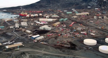
Currently the station is operated by the United States through the National Science Foundation (NSF) and is the largest community in Antarctica, capable of supporting up to 1,258 residents. It serves as an Antarctic science facility as well as a logistics base for half the continent. It has a harbor, 3 airfields (2 seasonal), a heliport and over 100 buildings.
The principal U.S. airfield in the white continent is Williams Field. It was named in honor of Richard T. Williams, a U.S.Navy equipment operator who died when his D-8 tractor broke through the ice during Operation Deep Freeze in 1956.
The airport, is located approximately seven miles from Ross Island, and serves McMurdo Station as well New Zealand?s Scott Base. It have a compacted snow runway lying on top of the Ross Ice Shelf which is nearly 80 meters thick. Is in operation from December through the end of February and can support ski-equipped aircraft landings only. A cluster of facilities for flight operations, referred to as "Willy Field," includes several rows of containers for a workers galley, fire and rescue equipment and even a movable control tower.
Balloons in Antarctica
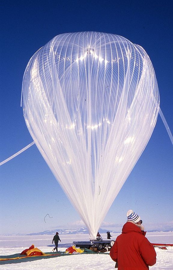
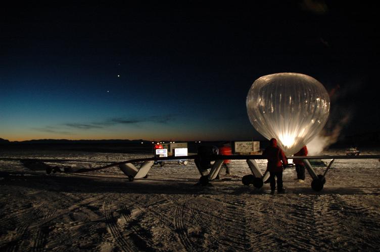
The great advantage of launchings balloons in Antarctica during summer lies in two factors: the so called polar vortex, and the constant solar radiation.
The vortex is a persistent, large, high-pressure system which forms a unique atmospheric circulation pattern over Antarctica. It allows scientists to launch balloons from a site and recover them from very nearly the same spot weeks later, after they have circled the continent one to three times. Regarding the solar factor, it is key to perform long duration flights because constant daylight in Antarctica means minimal day-to-night temperature fluctuations on the balloon, allowing zero pressure balloons to maintain a near constant altitude for a longer time.
Although NASA currently has the predominant effort with large heavy lift balloons in Antarctica since early 90's, as a matter of fact there were two two early pioneer efforts worth mentioning. The Japan space agency started to develop the so called "Polar Patrol Balloon" as early as 1984 with the first test flight done from the Syowa Antarctic Base in 1987. The objective of the project was to send small and medium size balloons in a round pole flight path, which achieved for the first time in Christmas 1990. The other project was the first launch of a large stratospheric balloon with a heavy payload which took place in January 1988 from Williams Field under operation of the balloon branch of the U.S. Air Force Holloman Base. The objective was to launch an instrument to observe gamma rays coming from the recently discovered supernova SN-1987A.
During the 1980s, NASA sponsored sporadic Long Duration Balloon (LDB) missions flown on standard zero pressure balloons from Alice Springs to South America. The interest of the scientific community in such extended flights led the agency to create a development team to design and build flight hardway and operational support hardware to conduct these missions on an annual basis. As a result of their work, in 1990 and 1991, NASA sponsored two remote campaigns in Antarctica for conducting LDB test flights which included science payloads as missions of opportunity. The launches took place from Williams Field airport during the austral summer of those years.
Basic Infrastructure
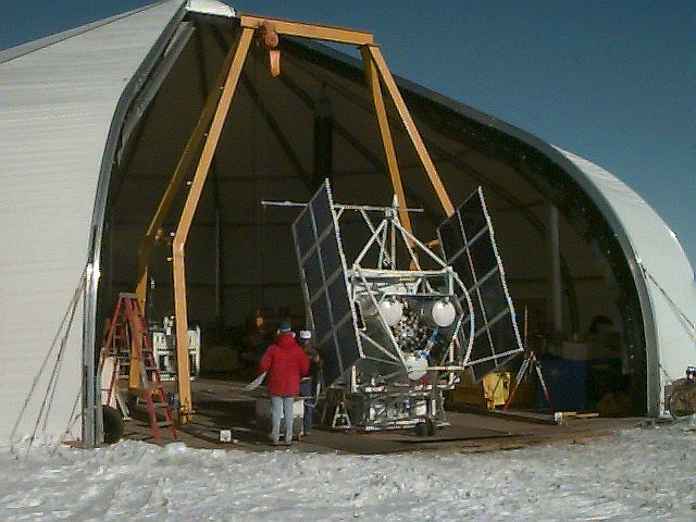
In 1992, NSBF established a permanent LDB support group as routine flight operations were planned for Antarctica. This included the purchase of a tent like building which was called the "Sprung Structure" used to host the payloads while being prepared for launch. At right can be seen a distant shot of it while the image at left shows the structure opened (click to enlarge both images). It was an aluminum framed cone shaped structure about 90 feet in diameter and 40 feet tall. The walls or "skin" of the construction were made of a fiberglass/Teflon material with one large clam shell type door in one side plus a couple of personnel doors. The structure was placed on top of plywood platforms on Williams Field. Inside the building was a rolling bridge crane on steel tracks with a 21 foot hook height to lift payloads.
At the end of each balloon campaign, the building had to be taken down to McMurdo and stored for the winter. The crane and the platforms instead, remained in place. Each spring, the contractor crew put together the building again. After one or two years of doing so, keeping the platforms level became a real problem due to the fact that they were progressivelly being covered by the snow.
In November 1995, as they had almost assembled the building, a storm hit Williams Field tearing the skin and bending the framework. This occurred about three weeks before the scientist were scheduled to start assembling the two payloads for that season. NSF decided to construct a building out of existing lumber at McMurdo that could be attached in the frOnt of a metal heavy equipment garage already present at Williams Field.
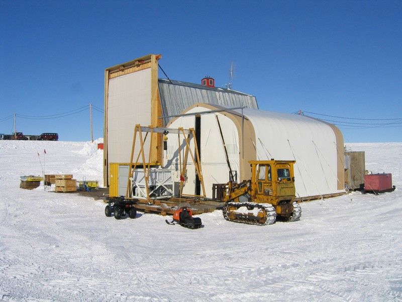
The new facility was put together by the local carpenters in a record time of about two weeks without formal plans. It was called the "Pig barn" because after completion they put a weather vane on top of the structure which had the image of a pig on it. The building comprised two parts. The large front section build by the carpenters was couvered with a great door made of canvas and wood slats that could be raised like shutters on a window. The back part was simply a steel building which originally was a heavy equipment maintenance shop, which was "attached" to the rear of the newly built building. The size of the bridge crane on the tracks is what dictated the final size of the Pig Barn.
Besides the improvement made, the snow accumulation problem remained. Each spring it took more and more time for the contractor to push away the snow and dig out the buildings so that they could be used for the NASA balloon operations.
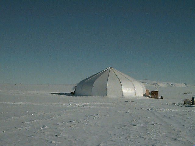
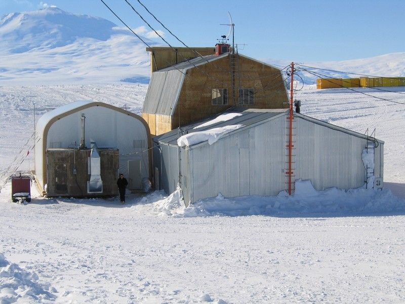
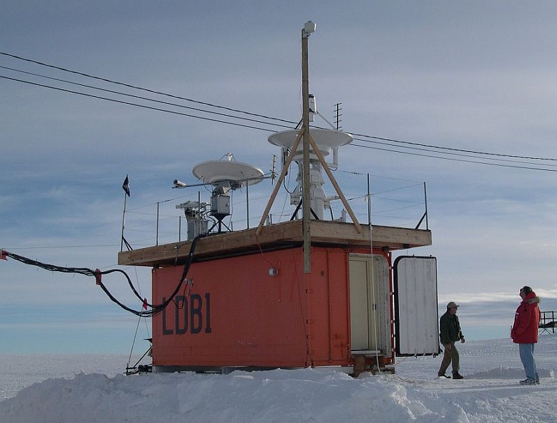
Additional science requirements led to needing a third payload assembly and test facility. NASA purchased another building known as "The Weatherport" which was located next to the "Pig barn" and intended to accommodate a smaller payload that did not require a crane inside or extra ceiling height. It was a tent structure made on a metal frame with an insulated covering slightly rounded on top that somewhat resembled the gone "Sprung Structure".
By 2000 the winter season snow covered the telemetry building completely (it was about 10 feet tall) and the "Pig Barn" had over twenty feet of snow on the windward side. It was taking about three weeks full time for two large bulldozers with very big curved tall blades to push away the snow. As this expense became unbearable, NASA and NSF made the decision to overcome the issue by creating a new set of movable buildings on skis that would be placed on snow berms over the winter so the snow would not bury them.
NASA paid for the six buildings, which were built on the Ross Ice Shelf near the transition to Ross Island about 2 miles from McMurdo Station during the winter 2005. The buildings were erected outside , where the workers had to face months of dark winter days with temperatures dipping into the negative 70s Celsius. After completion, in late September, the buildings were pulled one-by-one behind D-8 Caterpillar tractors in a slow parade to Williams Field. The last one was put into place on October 14, 2005.
In the picture bellow can be seen an aerial shot of the LDB field site.
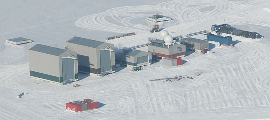
The first two buildings on the left are the payload assembly buildings. They are both identical. The next is the CSBF mechanical/rigging workshop. The telemetry building is the one with the domes on the top and the next at right is the "mechanical" building which has the heat exchangers and the toilets. The blue structure is the dual generator set, which has the waste heat exchangers on the exhaust system which are connected to the "mechanical" building which has the heat exchangers to provide hot fluid to the rest of the complex. Finally the small cylindrical building on the right is the Jamesway tent structure that is used as a kitchen for the facility.
Right now they are the tallest buildings in Antarctica and with a weight around 160,000 pounds each, they are certainly the largest moveable structures down there.
Now, at the end of the summer season, workers free the buildings from the locations where they are currently anchored and move them onto snow berms, where they will be re-anchored for storage. This eliminates the need to excavate the buildings at the end of every winter as occured before with the "Pig Barn" and the others facilities there.
A reoccurring problem is that the skis will often freeze to the snow after sitting still and immobilize the building. When it's time to move them, the skis are warmed by electical heating strips to melt the ice cementing the buildings in place. This frees them in a gentler way than many other methods such as using explosives.
Launch Operations
The nominal Antarctica LDB launch window is December 10 through January 10 each year. The opening of the launch window is determined by the establishment of the seasonal polar wind circulation pattern necessary to maintain trajectories over the continent. The end of this window is determined by the United States Antarctic Program (USAP) requirements to complete seasonal close-out and retrograde operations.
McMurdo lies at 77.86º south latitude so LDB trajectories tend to remain closest to the McMurdo latitude for those periods nearest the middle Austral summer season and tend to diverge for those periods nearest the beginning and end of the season when the stratospheric turnaround either has occurs or begins to occur.
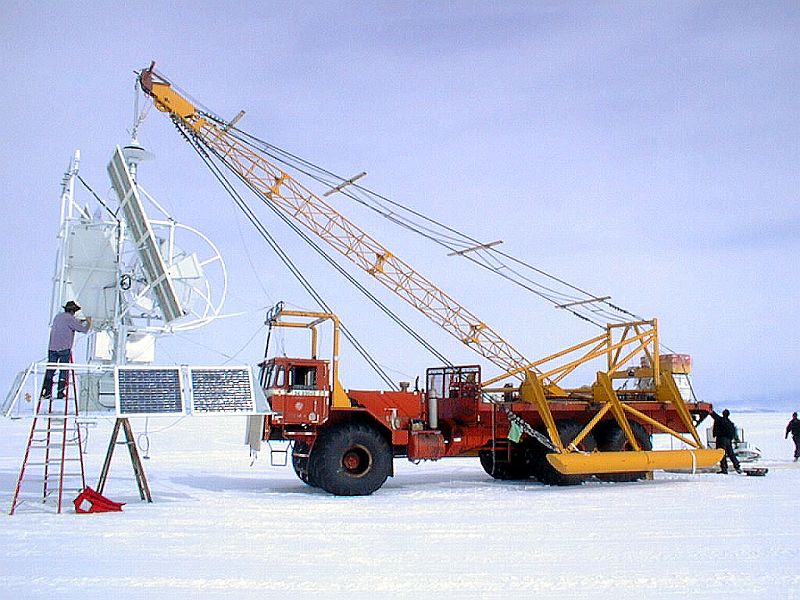
From the beginning of the balloon operations at Williams Field the launch method used is the "dynamic" technique. During the first 15 years the launch vehicle used for hold and maneuver the payload at launch time was a "DELTA III" special Antarctic truck on which was installed a large crane to hold the payloads. It had a load capacity limited to 2038 kg and low maneuverability. At left can be seen a picture of it (click to enlarge).
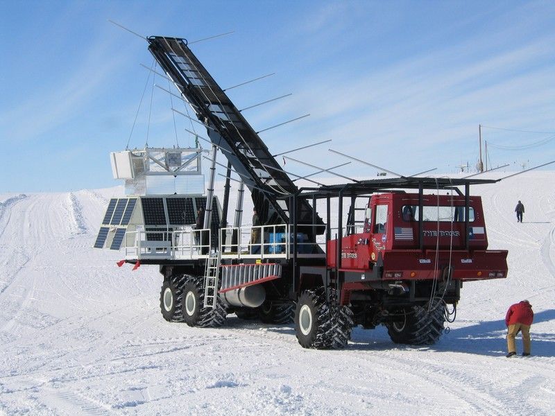
By 2002, NSBF has completed the fabrication of a new launch vehicle for use in Antarctica. It is named "The Boss" (after the popular name of the Antarctic explorer Ernest "The Boss" Shackleton) and is designed by engineers at the NSBF. At right can be seen a image of it (click to enlarge). The 40-ton truck is 58-feet long, with tires measuring over 4-feet tall. The vehicle is be able to travel through ice, snow, four feet of water with the ability to climb a 50 degree grade going forward and backward and traverse a 30 degree side slope. It is also able to operate in temperatures well below -50 degrees Fahrenheit and allows launch of heavier payloads (up to 3623 kgs).
Althought the new vehicle is much more versatile than the Delta III, it also need some "terrain preparation" before any launch. Currently it takes Raytheon (the main contractor for each campaign operational support at Williams Field) 3-4 weeks each year with a bulldozer and "sheepsfoot" roller to pack the launch area to eliminate any voids that might have occurred over the winter and to compact the surface. This is a key operation to make the field suitable for the operation with "The Boss" on that surface.
Balloon tracking
The original design for long distance communications during LDB flights was based in a combinations of INMARSAT and ARGOS/HF systems. INMARSAT used text messages to send commands and receive limited amounts of data to show flight status and ARGOS was a downlink to provide limited amount of flight status. HF was using a transmitter in McMurdo to send a limited amount of command data up to the balloon by means of amateur type radio transceivers both in the balloon and on the ground as a system to receive balloon status and send commands to the balloon.
Nevertheless, there was a problem with the HF system during the first two NASA LDB flights in 1989 causing the premature activation of the of the separation cable cutters. Apparently some ground loop currents along the flight train induced by the HF system fired the termination squibs. The HF transmitter on the balloon was eliminated after those two flights.
Early in the LDB flights from Antarctica it was very difficult to get any large amount of scientific data in real time from the balloon. If the scientist wanted real time data, they had to provide their own transmitter/antenna system even for Line of Sight coverage. So the must common data storage system was onboard disks, thus making recovery of the instrument after the flight a key issue for the success of the mission.
Several solutions were studied at some point, including the cache of solar-powered automatic telemetry relay stations at several points along likely flight paths just before balloon flight season or even the use of small superpressure balloons to serve as link between ground station and the balloon in flight. Nevertheless, these two concepts never left the design tables. In the mid-90s, the NSBF LDB group developed the use of TDRSS low cost transponders to increase the real time data rate during reliable duplex coverage of Antarctica LDB balloon flights. With this development, monitoring of Antarctica LDB balloon science data and status began at NSBF in Palestine, Texas. Additionally full command capability was established to the LDB flight support and science systems.
Capitalizing upon NASA's Ultra Long Duration Balloon (ULDB) Development Program, NSBF performed a key change in December 2004 when during the CREAM balloon flight, for the first time in Antarctic LDB missions, transmited a significant fraction of science and housekeeping data collected (up to 85 kbps) in near real-time through the Tracking and Data Relay Satellite System (TDRSS) via a new steerable high-gain antenna, as well as keeping an onboard data archive. Also the balloon was controlled through a line of sight (LOS) transmitter from pre-launch until it went over the horizon, about 12 hours post launch, at which point commanding was transferred off the continent to the Science Operations Center (SOC) at the University of Maryland and NASA's Wallops Flight Facility (WFF) Engineering Support Center (ESC). Primary command uplink was via TDRSS, with Iridium serving as backup when the primary link was unavailable due to schedule or zone of exclusion (ZOE) traverse.
This near-continuous availability of command uplink and data down-link throughout the flight allowed a robust response to changing conditions on the payload and a much more close surveillance of the health of the system.
Flight termination and payload recovery
The termination procedure is carried out from a Hercules C-130 plane which is sent to within Line of Sight of the balloon location to send the commands to terminate the flight. For this purpose a small equipment rack was designed and built specifically to fit on a C-130 cargo pallet containing the telemetry equipment and command system. A command/telemetry antenna was fabricated into an escape hatch on top of the C-130 which can be substituted for the normal hatch when the plane is used for the balloon termination operations. At left can be seen a CSBF technician operating the equipment to end the ATIC flight in 2007.


Since the introduction of the automatic self contained parachute cut-away system, LDB balloon flights have been terminated from the Palestine, Texas operations center. Prior to that time, the C-130 was required to watch the payload on the parachute hit the ground so that a manual command could be sent from the plane at that time to release the parachute preventing the chute to become a sail and dragging the payload on the ground.
While Antarctic flights have an excellent record of success, payload recovery has often been less than straightforward. This is due to the fact that many previous balloon flight gondolas have not been designed with the specific requirements for Antarctic recovery (especially the need for breakdown in the field) as a primary design constraint.
At least in principle, it is possible to land a C-130 heavy-lift cargo aircraft anywhere within a large fraction of the Antarctic land mass, and thus recover the largest balloon payload flyable intact, or with minimum field disassembly. In practice, a number of severe constraints apply. First, US Antarctic Program will certainly not risk aircraft and crews, except for rescue operations when the proposed landing area poses significant hazards. Helicopters and Twin-Otter aircraft can be safely landed in many locations where a C-130 could never venture safely.
As balloons are typically launched in late December through late January, the recovery operations are carried out in mid to late February, the time when the program is performing the winter shutdown activities. At this time, aircraft sorties are heavily booked, with highest priority assigned for field team recovery over hardware recovery.
As an additional complication, recovery operations often take place in very bad weather, where the recovery team may have limited time to work before they must abandon the site. Also depending on the altitude of the landing place, the physical capacity of their members is limited. On regard this last item, after difficult experiences performing recoveries from high ice plateau altitudes, flight termination and recovery is now planned only over regions of lower elevation.
The well established logistical systems used by the United States to support the NSF McMurdo Station have made it easier for NASA to ship balloons, support equipment, science payloads, and supplies to Antarctica than to remote locations in Canada, such as Lynn Lake, Manitoba. The overall cost to support the logistical requirements of the NASA LDB Program will continue to be a budgetary issue in the future.
Althought rare, in some oportunities there were balloon launches not included in NASA's LDB effort. The most recent campaign took place between August and October 2005 from the same Williams field launch area, by a French scientific party which came to the white continent to launch superpressure balloons under the so called VORCORE campaign.
Throughout almost 80 days a team of scientists of the Laboratoire de Meteorologie Dynamique of the French research agency CNRS and technicians of the balloon division of the space agency CNES sent a total of 27 such small balloons, wich followed the same circular pattern around the south pole as their bigger American's cousins.
Finally, is worth to mention that aside the balloon operations at Williams Field, several other balloon campaigns took place at McMurdo over the years. For instance a bunch of scientific teams from several agencies and Universities had performed small balloon launches at McMurdo. These launches are made using small devices which allow to perform those flights without the need of specialized hardware and even must of these launches are carried out by hand by the scientists itself.
Balloons launched from Williams Field airport
| Date | Hour | Flight Duration | Experiment | Payload landing place or cause of the failure |
|---|---|---|---|---|
| 1/8/1988 | 12:15 local time | 3 d | GRAD (Gamma Ray Advanced Detector) | 320 km east of Russian Vostok Station, Antarctica |
| 1/12/1989 | --- | PATHFINDER | --- No Data --- | |
| 1/19/1989 | --- | PATHFINDER | --- No Data --- | |
| 1/21/1989 | --- | PATHFINDER | --- No Data --- | |
| 1/1/1990 | 17:56 utc | 20 m | GAMMA RAY / X-RAY / COSMIC RAY DETECTOR | 1/2 mile from launch pad |
| 1/8/1990 | 7:17 utc | 3 h | X-RAY DETECTOR | 2 miles W of Williams Field, Antarctica |
| 12/21/1990 | 18:50 utc | 8 d 17 h 39 m | JACEE 10 + ANTIPODE + PAX | 113 miles SE of McMurdo Station, Antarctica |
| 12/16/1991 | 17:25 utc | 9 d 5 h | MAGPIE (Magnetic Passive Isotope Experiment) | --- No Data --- |
| 1/10/1992 | 9:45 utc | ~ 13 d | HIREGS I (HIgh REsolution Gamma-ray and hard x-ray Spectrometer) | In the Antarctic plateau, at coordinates 86.2º S and 160.5º E |
| 12/13/1992 | 22:52 utc | ~ 13 d | LAMB (Long Duration Antarctic Mars Calibration Balloon) | In the Ross Ice Shelf, Antarctica |
| 12/31/1992 | 4:00 utc | ~ 10 d | HIREGS II (HIgh REsolution Gamma-ray and hard x-ray Spectrometer) | In the Ross Ice Shelf, Antarctica |
| 12/14/1993 | 3:58 utc | ~ 10 d | JACEE 11 (Japanese-American Collaborative Emulsion Experiment) | It sunked in Wohlschlag Bay off Cape Royds in the Ross Sea, Antarctica. Never recovered. |
| 1/2/1994 | 00:44 utc | ~ 9 d | JACEE 12 (Japanese-American Collaborative Emulsion Experiment) | 443 miles ESE of McMurdo, Antarctica |
| 12/21/1994 | 23:12 utc | ~ 13 d | JACEE 13 (Japanese-American Collaborative Emulsion Experiment) | Victoria Land at 73 45' S, 152 22' E in Antarctica |
| 1/8/1995 | 3:38 utc | 24 d | HIREGS III (HIgh REsolution Gamma-ray and hard x-ray Spectrometer) | 400 km southeast of launch site |
| 12/19/1995 | 7:41 utc | 14 d 5 h | JACEE 14 (Japanese-American Collaborative Emulsion Experiment) | 93 miles S of McMurdo, Antarctica |
| 1/7/1996 | 7:01 utc | 19 d | FGE (Flare Genesis Experiment) | 138 miles from Dumont d'Urville, Antarctica |
| 1/7/1998 | 4:57 utc | ~ 4 d | HIREGS IV (HIgh REsolution Gamma-ray and hard x-ray Spectrometer) | 180 miles from Vostok Station, Antarctica |
| 12/29/1998 | 3:28 utc | 10.5 d | BOOMERANG (Balloon Observations of Millimetric Extragalactic Radiation and Geophysics) | 50 km N of McMurdo Base, Antarctica |
| 1/10/2000 | 3:13 utc | 17 d | FGE (Flare Genesis Experiment) | Near McMurdo base, Antarctica |
| 1/11/2000 | 23:55 utc | 18 d | MAXIS (MeV Auroral X-ray Imaging and Spectroscopy) | 390 miles NW from McMurdo Station, Antarctica |
| 12/28/2000 | 4:28 utc | 17 d | ATIC-1 (Advanced Thin Ionization Calorimeter) | At 75º 30' S 154º 5' E, Antarctica |
| 1/4/2001 | 7:08 utc | ~ 27 d | TOP HAT | Bottom payload impact at 85º 5.66' S 164º 52.15' W. Balloon and telescope impact 85º 8' 54" S, 164º 26' 31" W. Antarctica |
| 12/20/2001 | 12:30 local | 31 d 24.5 h | TIGER (Trans-Iron Galactic Element Recorder) | 250 miles SSE of McMurdo station, Antarctica |
| 12/29/2002 | 5:00 utc | 19 d 21 h | ATIC-2 (Advanced Thin Ionization Calorimeter) | 65 miles WSW of Terra Nova Base, Antarctica |
| 1/6/2003 | 4:48 utc | 10 d | BOOMERANG (Balloon Observations of Millimetric Extragalactic Radiation and Geophysics) | 69 miles S of Dome Fuji Station, Antarctica |
| 12/9/2003 | ~ 13:00 local | --- | PATHFINDER | Lost over Pacific Ocean. |
| 12/12/2003 | 6:09 utc | 14 d | TRACER (Transition Radiation Array for Cosmic Energetic Radiation) | 121 miles W of McMurdo Station, Antarctica |
| 12/15/2003 | 9:40 utc | ~ 30 h | MINIS (Miniature Spectrometer) | Last known position 77.68 S, 127.87 E - Not recovered |
| 12/17/2003 | 4:07 utc | 18 d | TIGER (Trans-Iron Galactic Element Recorder) | 270 miles WSW of Mawson Station, Antarctica |
| 12/13/2004 | 5:54 utc | 8 d 17 h | BESS POLAR I (Balloon-borne Experiment with a Superconducting Spectrometer - POLAR VERSION) | 103 miles SW of Siple Dome, Antarctica |
| 12/16/2004 | 4:28 utc | 41 d 22 h | CREAM I (Cosmic Ray Energetics And Mass) | 410 miles SSE of McMurdo Station, Antarctica |
| 9/5/2005 | 20:30 (?) | 6 d | RUMBA | Last known position: 78.36º S - 116.78º E. |
| 9/6/2005 | 90 d | RUMBA | Last known position: 64.25º S - 175.08º W | |
| 9/9/2005 | 57 d | RUMBA | Over the argentinian patagonic coast. Last known position: 48.65º S - 61.71º W | |
| 9/9/2005 | 86 d | RUMBA | On the Atlantic Ocean. Last known position: 42.66º S - 33.45º W | |
| 9/12/2005 | 15 d | RUMBA | Last known position: 77.60º S - 79.66º E | |
| 9/17/2005 | 91 d | RUMBA | On the Pacific Ocean. Last known position: 39.83º S - 151.04º W | |
| 9/17/2005 | 1 h | RUMBA | Near the launch site (76.84º S - 166.45º E) | |
| 9/20/2005 | 109 d | RUMBA | On the Indian Ocean. Last known position: 39.70º S - 78.10º E | |
| 9/22/2005 | 87 d | RUMBA | On the Pacific Ocean. Last known position: 39.70º S - 164.07º W | |
| 9/22/2005 | 2 d | RUMBA | On the Antarctic Ocean. Last known position: 71.30º S - 118.47º W | |
| 9/23/2005 | 95 d | RUMBA | On the Antarctic Ocean. Last known position: 58.01º S - 105.64º E | |
| 9/23/2005 | 13 d | RUMBA | Last known position: 64.00º S - 61.98º W | |
| 9/26/2005 | 79 d | RUMBA | On the Antarctic Ocean. Last known position: 63.12º S - 37.33º W | |
| 9/28/2005 | 89 d | RUMBA | Last known position: 77.29º S - 42.34º E | |
| 10/3/2005 | 64 d | RUMBA + TURBULENCE | Last known position: 68.14º S - 114.35º E | |
| 10/5/2005 | 75 d | RUMBA | On the Pacific Ocean. Last known position: 39.89º S - 167.91º W | |
| 10/5/2005 | 93 d | RUMBA | On the Antarctic Ocean. Last known position: 56.29º S - 10.61º E | |
| 10/5/2005 | 28 d | RUMBA | Last known position: 74.65º S - 27.87º E | |
| 10/13/2005 | 17 d + 93 d | RUMBA + TURBULENCE | On the Antarctic Ocean. Last known position: 72.00º S - 10.00º W | |
| 10/13/2005 | 93 d | RUMBA | On the Pacific Ocean. Last known position: 48.70º S - 100.37º W | |
| 10/14/2005 | 1 h | RUMBA | Near the launch site (77.78º S - 169.18º E) | |
| 10/16/2005 | 62 d | RUMBA | On the Indian Ocean. Last known position: 39.87º S - 29.35º E | |
| 10/18/2005 | 66 d | RUMBA | On the Indian Ocean. Last known position: 39.87º S - 23.22º E | |
| 10/25/2005 | 51 d | RUMBA | On the Pacific Ocean. Last known position: 39.63º S - 166.44º W | |
| 10/25/2005 | 94 d | RUMBA + TURBULENCE | On the Pacific Ocean. Last known position: 52.98º S - 122.43º O | |
| 10/26/2005 | 17 d | RUMBA | On the Indian Ocean. Last known position: 39.40º S - 74.98º E | |
| 10/28/2005 | 96 d | RUMBA | On the Indian Ocean. Last known position: 51.00º S - 76.00º E | |
| 12/15/2005 | 16:12 | 28 d 9 h 52 m | CREAM II (Cosmic Ray Energetics And Mass) | 249 nautic miles Northwest from McMurdo Antarctic base. |
| 12/19/2005 | 5:18 utc | 4 h 11 m | ATIC-3 (Advanced Thin Ionization Calorimeter) | In the Ross Ice Shelf, 70 nm E of McMurdo Station, Antarctica |
| 12/14/2006 | 23:40 local | 35 d 1h 29 m | ANITA I (Antarctic Impulse Transient Antenna) | At coordinates, 84º 33' S, 22º 07' W in the Antarctic Plateau |
| 12/21/2006 | 1:53 utc | 11 d 23 h 12 m | BLAST (Balloon-borne Large Aperture Sub-millimeter Telescope) | W of Transantarctic Mountains, approximately 410 nm SW of McMurdo Station |
| 12/24/2006 | 3:57 utc | 5 h 23 m | SBI (Solar Bolometric Imager) | 54 miles E-SE of Williams Field, Antarctica |
| 12/19/2007 | 3:29 | 28 d 21 h 53 m | CREAM III (Cosmic Ray Energetics And Mass) | 177 nautic miles SW from McMurdo Antarctic base |
| 12/23/2007 | 30 d 15 h 37 m | BESS POLAR II (Balloon-borne Experiment with a Superconducting Spectrometer - POLAR VERSION) | 225 nautic miles SE of the Patriot Hills Station. | |
| 12/26/2007 | 14:33 | 19 d 10 h 43 m | ATIC-4 (Advanced Thin Ionization Calorimeter) | 231 nautic miles NE of the Amundsen-Scott South Pole Station, Antarctica |
| 12/19/2008 | 21:54 | 19 d 13 h | CREAM IV (Cosmic Ray Energetics And Mass) | 560 nautic miles N-NW of McMurdo Station, Antarctica |
| 12/21/2008 | 10:17 local | 30 d 16 h | ANITA II (Antarctic Impulse Transient Antenna) | 122 NM southwest of Siple Dome, Antarctica |
| 12/28/2008 | 15:30 local | 54 d 1 h 29 m | ULDB (Ultra Long Duration Balloon) | Filchner Ice Sheet, Antarctica |
| 11/25/2009 | 7 d | PATHFINDER | Payload no recoverable | |
| 12/1/2009 | 21:21 utc | 37 d | CREAM V (Cosmic Ray Energetics And Mass) | 185 nautic miles SSE of McMurdo, Antarctica |
| 12/2/2009 | 1:56 utc | 6 d 16 h | BARREL #1 (Balloon Array for RBSP Relativistic Electron Losses) | In coordinates 69.56º S - 125.40º E, Antarctica |
| 12/6/2009 | 1:30 utc | 10 h 10 m | BARREL #2 (Balloon Array for RBSP Relativistic Electron Losses) | 140 nm NW of McMurdo, Antarctica |
| 12/10/2009 | 10:21 utc | 3 h | ULDB (Ultra Long Duration Balloon) | --- No Data --- |
| 12/13/2009 | 00:11 utc | 16 h | PATHFINDER | Payload no recoverable |
| 12/15/2009 | 2:09 utc | --- | BARREL #3 (Balloon Array for RBSP Relativistic Electron Losses) | 230 nautic miles NE from South Pole Station, Antarctica |
| 12/16/2009 | 22:30 utc | --- | BARREL #4 (Balloon Array for RBSP Relativistic Electron Losses) | 405 miles SW of McMurdo, Antarctica |
| 12/11/2010 | 18:15 utc | --- | PATHFINDER | Over the Wedell Sea |
| 12/13/2010 | 21:52 utc | 6 d 3 h | BARREL #1 (Balloon Array for RBSP Relativistic Electron Losses) | Over the Southern Ocean |
| 12/18/2010 | 1 d | BARREL #2 (Balloon Array for RBSP Relativistic Electron Losses) | Over Antarctica | |
| 12/21/2010 | 1:42 utc | 5 d 16 h 28 m | CREAM VI (Cosmic Ray Energetics And Mass) | Over Queen Maud Land, Antarctica |
| 12/27/2010 | 4:06 utc | 9 d 17 h 9 m | BLAST-Pol (Balloon-borne Large Aperture Sub-millimeter Telescope for Polarization) | 330 Nautic Miles SSE of McMurdo Station, Antarctica |
| 1/9/2011 | 22:46 utc | 22 d 2 h | ULDB (Ultra Long Duration Balloon) | 483 miles NNW of McMurdo Station, Antarctica |
| 12/11/2011 | 11 d | PATHFINDER | Payload no recoverable | |
| 12/24/2011 | --- | PATHFINDER | Payload no recoverable | |
| 12/25/2011 | 2:20 utc | 10 d 13 h | CREST (Cosmic Ray Electron Synchrotron Telescope) | 55 nm W of the Italian Antarctic Station at Terra Nova Bay |
| 12/27/2011 | --- | PATHFINDER | Payload no recoverable | |
| 1/10/2012 | --- | STO (Stratospheric Terahertz Observatory) | Aborted launch | |
| 1/14/2012 | 20:50 utc | 13 d 10 h | STO (Stratospheric Terahertz Observatory) | At coordinates 79º 31' S 176º 16' E, Antarctica. |
| 12/3/2012 | --- | PATHFINDER | Payload no recoverable | |
| 12/8/2012 | 20:45 utc | 55 d 2 h 32 m | Super-TIGER I (Trans-Iron Galactic Element Recorder) | At coordinates 82° 14.75 S, 81° 54.83 W, Antarctica. |
| 12/25/2012 | 18:58 utc | 16 d 3 h 17 m | BLAST-Pol (Balloon-borne Large Aperture Sub-millimeter Telescope for Polarization) | 270 miles SSE of McMurdo Station, Antarctica |
| 12/29/2012 | 2:30 utc | 25 d 11 h 39 m | EBEX (E AND B EXPERIMENT) | 351 miles NNW of McMurdo Station, Antarctica |
| 12/17/2014 | 21:24 utc | 22 d 9 h 14 m | ANITA III (Antarctic Impulsive Transient Antenna) | 100 miles from Australia's Davis Station, Antarctica |
| 12/19/2014 | 4 d 20 h | ANITA Hi-Cal (Antarctic Impulsive Transient Antenna High Altitude Calibration) | Payload no recoverable | |
| 12/28/2014 | 21:24 UTC | 1 d 19 h | SPB (Super Pressure Balloon) + COSI (Compton Spectrometer and Imager Science) | 350 miles from McMurdo Station, Antarctica |
| 1/1/2015 | 16 d 12 h | SPIDER (Suborbital Polarimeter for Inflation Dust and the Epoch of Reionization) | SE of Siple station, Antarctica | |
| 1/6/2015 | 5 d 13 h | ANITA Hi-Cal (Antarctic Impulsive Transient Antenna High Altitude Calibration) | Payload no recoverable | |
| 1/19/2016 | 1:40 utc | 11 d 19 h 50 m | GRIPS (Gamma-Ray Imager/Polarimeter for Solar flares) | 83°6.18 S - 40°54.08 W. East of Pensacola Mountains. Antarctica |
| 11/28/2016 | 19:15 utc | 30 d 2 h 1 m | BACCUS (Boron And Carbon Cosmic rays in the Upper Stratosphere) | 50 miles E of McMurdo Station |
| 12/2/2016 | 13:11 utc | 27 d 16 h 52 m | ANITA IV (Antarctic Impulsive Transient Antenna) | Near the Amundsen-Scott base in the south pole |
| 12/8/2016 | 20:53 utc | 21 d 19 h 17 m | STO-2 (Stratospheric Terahertz Observatory II) | In the Ross ice Shelf, 340 nautical miles NW of McMurdo |
| 12/11/2016 | 21:40 utc | 13 d 12 h 39 m | ANITA Hi-Cal 2 (Antarctic Impulsive Transient Antenna High Altitude Calibration) | Payload no recoverable |
| 12/12/2016 | 20:15 utc | 5 d 23 h 1 m | ANITA Hi-Cal 2 (Antarctic Impulsive Transient Antenna High Altitude Calibration) | Payload no recoverable |
| 12/9/2018 | 18:50 utc | 74 d | BARREL 6A + GUSTO PATHFINDER | In the Amundsen Sea, 500 nautic miles west of Charcot Islands in the Antarctic Peninsula |
| 12/19/2018 | 12:36 utc | 6 h 41 m | Super-TIGER II (Trans-Iron Galactic Element Recorder) | 280 km al NNW of McMurdo Station, Antarctica |
| 12/30/2018 | 0:10 utc | 2 d | X-CALIBUR / WASP | At coordinates -79.2902º S 94.7048º E in the Antarctic Plateau. |
| 12/15/2019 | 2:55 NZDT | 32 d 23 h | Super-TIGER II (Trans-Iron Galactic Element Recorder) | In the Antarctic Plateau at coordinates 71°7.53 S - 158°35.10 E |
| 12/29/2019 | 149 d | TRAVALB (Trajectory Validation - BARREL) | Last known position lat: -57.5178º lon: -162.4834º | |
| 1/6/2020 | 5:00 utc | ~ 20 h | BLAST-TNG (Balloon-borne Large Aperture Sub-millimeter Telescope - The Next Generation) | --- No Data --- |
| 12/21/2022 | 21:25 utc | 16 d 7 h | SPIDER (Suborbital Polarimeter for Inflation Dust and the Epoch of Reionization) | Near the Hercules Dome field camp, about 430km from the South Pole |
| 12/10/2023 | 23:00 utc | 15 d 17 h | LAURA (Long durAtion evalUation solaR hand Launch) | In the Ronne Ice Shelf, 170 km S of Belgrano II base, Antarctica |
| 12/31/2023 | 6:35 utc | 57 d 7 h 38 m | GUSTO (Galactic / Extragalactic ULDB Spectroscopic Terahertz Observatory) | 380 km S of Mawson Station, Antarctica |
| 1/10/2024 | 2:33 utc | 46 h | AESOP-Lite + ANIHALA | In the Antarctic Plateau, 77 km NE of Dome Argus |
| 12/21/2024 | 21:58 UTC | 11 d 6 h 57 m | SALTER TEST FLIGHT UNIVERSAL | 205 km ENE from McMurdo Station |
| 12/15/2025 | 16:30 UTC | 25 d 2 h 53 m | GAPS (General AntiParticle Spectrometer) | 60 km al SE de la Estacion McMurdo, Antartida |
| 12/19/2025 | 16:56 UTC | 23 d 9 h 52 m | PUEO (Payload for Ultrahigh Energy Observations) | In the East Antarctic Plateau, 255 km from the South Pole, Antarctica |
| 12/20/2025 | 5 d 2 h 6 m | HICAL II | On the East Antarctic Ice Sheet, near Queen Maud Land, Antarctica | |
| 12/20/2025 | 12 d 12 m | HICAL I | On the Ross Ice Shelf, Antarctica |
Balloons launched from McMurdo station and around
| Date | Hour | Flight Duration | Experiment | Payload landing place or cause of the failure |
|---|---|---|---|---|
| 10/27/1982 | 1 h 30 m | --- NO DATA --- | --- No Data --- | |
| 8/22/2004 | 00:00 utc | 2 h 12 m | OZONE SONDE | --- No Data --- |
| 8/24/2004 | 20:09 utc | 2 h 10 m | OZONE SONDE | --- No Data --- |
| 8/28/2004 | 7:26 utc | 1 h 50 m | OZONE SONDE | --- No Data --- |
| 9/1/2004 | 3:35 utc | 2 h 20 m | OZONE SONDE | --- No Data --- |
| 9/3/2004 | 18:28 utc | 2 h 18 m | OZONE SONDE | --- No Data --- |
| 9/7/2004 | 3:07 utc | 2 h 20 m | OZONE SONDE | --- No Data --- |
| 9/9/2004 | 2:38 utc | 1 h 45 m | OZONE SONDE | --- No Data --- |
| 9/11/2004 | 21:50 utc | 1 h 55 m | OZONE SONDE | --- No Data --- |
| 9/15/2004 | 10:04 utc | 2 h 15 m | OZONE SONDE | --- No Data --- |
| 9/22/2004 | 9:35 utc | 1 h 45 m | OZONE SONDE | --- No Data --- |
| 9/24/2004 | 2:24 utc | 2 h 6 m | OZONE SONDE | --- No Data --- |
| 9/27/2004 | 7:26 utc | 2 h 25 m | OZONE SONDE | --- No Data --- |
| 9/30/2004 | 1:40 utc | 2 h 30 m | OZONE SONDE | --- No Data --- |
| 10/2/2004 | 1:55 utc | 2 h 30 m | OZONE SONDE | --- No Data --- |
| 10/6/2004 | 1:55 utc | 2 h 25 m | OZONE SONDE | --- No Data --- |
| 10/8/2004 | 22:19 utc | 2 h 45 m | OZONE SONDE | --- No Data --- |
| 10/13/2004 | 9:07 utc | 1 h 40 m | OZONE SONDE | --- No Data --- |
| 10/16/2004 | 7:11 utc | 1 h 40 m | OZONE SONDE | --- No Data --- |
| 10/18/2004 | 9:21 utc | 1 h 35 m | OZONE SONDE | --- No Data --- |
| 10/23/2004 | 3:07 utc | 2 h 30 m | OZONE SONDE | --- No Data --- |
| 10/26/2004 | 2:09 utc | 1 h 10 m | OZONE SONDE | --- No Data --- |
| 10/30/2004 | 3:35 utc | 1 h 20 m | OZONE SONDE | --- No Data --- |
| 10/31/2004 | 1:26 utc | 2 h 40 m | OZONE SONDE | --- No Data --- |
| 8/21/2005 | 4:33 utc | 1 h 45 m | OZONE SONDE | --- No Data --- |
| 8/24/2005 | 5:02 utc | 2 h 13 m | OZONE SONDE | --- No Data --- |
| 8/26/2005 | 8:09 utc | 1 h 45 m | OZONE SONDE | --- No Data --- |
| 8/28/2005 | 22:04 utc | 2 h 18 m | OZONE SONDE | --- No Data --- |
| 8/31/2005 | 10:33 utc | 1 h 40 m | OZONE SONDE | --- No Data --- |
| 9/2/2005 | 23:02 utc | 2 h 25 m | OZONE SONDE | --- No Data --- |
| 9/6/2005 | 2:09 utc | 2 h 30 m | OZONE SONDE | --- No Data --- |
| 9/9/2005 | 2:09 utc | 2 h 11 m | OZONE SONDE | --- No Data --- |
| 9/10/2005 | 12:43 utc | 1 h 13 m | OZONE SONDE | --- No Data --- |
| 9/12/2005 | 1:26 utc | 2 h 20 m | OZONE SONDE | --- No Data --- |
| 9/12/2005 | 22:19 utc | 2 h 15 m | OZONE SONDE | --- No Data --- |
| 9/16/2005 | 7:55 utc | 2 h 25 m | OZONE SONDE | --- No Data --- |
| 9/20/2005 | 00:00 utc | 2 h 23 m | OZONE SONDE | --- No Data --- |
| 9/22/2005 | 5:31 utc | 2 h 30 m | OZONE SONDE | --- No Data --- |
| 9/23/2005 | 22:48 utc | 2 h 15 m | OZONE SONDE | --- No Data --- |
| 9/26/2005 | 12:00 utc | 1 h 30 m | OZONE SONDE | --- No Data --- |
| 9/27/2005 | 1:40 utc | 1 h 37 m | OZONE SONDE | --- No Data --- |
| 9/28/2005 | 12:43 utc | 2 h 15 m | OZONE SONDE | --- No Data --- |
| 10/3/2005 | 10:19 utc | 2 h 35 m | OZONE SONDE | --- No Data --- |
| 10/5/2005 | 19:11 utc | 2 h 30 m | OZONE SONDE | --- No Data --- |
| 10/13/2005 | 23:45 utc | 2 h 40 m | OZONE SONDE | --- No Data --- |
| 10/16/2005 | 20:24 utc | 2 h 20 m | OZONE SONDE | --- No Data --- |
| 10/21/2005 | 1:40 utc | 5 h | OZONE SONDE | --- No Data --- |
| 10/24/2005 | 1:26 utc | 2 h 50 m | OZONE SONDE | --- No Data --- |
| 10/25/2005 | 22:48 utc | 2 h 20 m | OZONE SONDE | --- No Data --- |
| 10/29/2005 | 2:52 utc | 2 h 40 m | OZONE SONDE | --- No Data --- |
| 10/31/2005 | 21:21 utc | 2 h 30 m | OZONE SONDE | --- No Data --- |
| 11/3/2005 | 2:38 utc | 2 h | OZONE SONDE | --- No Data --- |
| 8/21/2006 | 3:35 utc | 2 h 15 m | OZONE SONDE | --- No Data --- |
| 8/22/2006 | 23.30 utc | 1 h 45 m | OZONE SONDE | --- No Data --- |
| 8/27/2006 | 23:16 utc | 1 h 45 m | OZONE SONDE | --- No Data --- |
| 8/28/2006 | 19:40 utc | 1 h 45 m | OZONE SONDE | --- No Data --- |
| 9/1/2006 | 20:38 utc | 1 h 40 m | OZONE SONDE | --- No Data --- |
| 9/3/2006 | 23:16 utc | 1 h 45 m | OZONE SONDE | --- No Data --- |
| 9/9/2006 | 10:19 utc | 1 h 30 m | OZONE SONDE | --- No Data --- |
| 9/9/2006 | 00:57 utc | 2 h 15 m | OZONE SONDE | --- No Data --- |
| 8/24/2009 | --- | AEROSOL & OZONE MEASUREMENTS | --- No Data --- | |
| 8/27/2009 | --- | AEROSOL & OZONE MEASUREMENTS | --- No Data --- | |
| 9/1/2009 | --- | AEROSOL & OZONE MEASUREMENTS | --- No Data --- | |
| 9/4/2009 | --- | AEROSOL & OZONE MEASUREMENTS | --- No Data --- | |
| 9/7/2009 | --- | AEROSOL & OZONE MEASUREMENTS | --- No Data --- | |
| 9/10/2009 | --- | AEROSOL & OZONE MEASUREMENTS | --- No Data --- | |
| 9/13/2009 | --- | AEROSOL & OZONE MEASUREMENTS | --- No Data --- | |
| 9/16/2009 | --- | AEROSOL & OZONE MEASUREMENTS | --- No Data --- | |
| 9/19/2009 | --- | AEROSOL & OZONE MEASUREMENTS | --- No Data --- | |
| 9/25/2009 | --- | AEROSOL & OZONE MEASUREMENTS | --- No Data --- | |
| 9/28/2009 | --- | AEROSOL & OZONE MEASUREMENTS | --- No Data --- | |
| 9/29/2009 | --- | AEROSOL & OZONE MEASUREMENTS | --- No Data --- | |
| 10/2/2009 | --- | AEROSOL & OZONE MEASUREMENTS | --- No Data --- | |
| 10/7/2009 | --- | AEROSOL & OZONE MEASUREMENTS | --- No Data --- | |
| 10/10/2009 | --- | AEROSOL & OZONE MEASUREMENTS | --- No Data --- | |
| 10/22/2009 | --- | AEROSOL & OZONE MEASUREMENTS | --- No Data --- | |
| 8/20/2010 | --- | OZONE SONDE | --- No Data --- | |
| 8/22/2010 | --- | OZONE SONDE | --- No Data --- | |
| 8/26/2010 | --- | OZONE SONDE | --- No Data --- | |
| 8/27/2010 | --- | OZONE SONDE | --- No Data --- | |
| 8/29/2010 | --- | DUAL INSTRUMENT OF CONDENSATION NUCLEI | --- No Data --- | |
| 9/1/2010 | --- | OZONE SONDE | --- No Data --- | |
| 9/4/2010 | --- | OZONE SONDE | --- No Data --- | |
| 9/8/2010 | --- | OZONE SONDE | --- No Data --- | |
| 9/9/2010 | 9:00 local | 7 d | TSEN + LMDOz + WPC | 80 km from McMurdo station, Antarctica |
| 9/11/2010 | 3:00 utc | 30 d | TSEN + UCOz + WPC | 130 km from McMurdo station, Antarctica |
| 9/11/2010 | --- | OZONE SONDE | --- No Data --- | |
| 9/14/2010 | 1:50 utc | 86 d | TSEN + UCOz + WPC | Over Tasmania Island, Oceania |
| 9/14/2010 | --- | OZONE SONDE | --- No Data --- | |
| 9/15/2010 | 3:10 utc | 96 d | TSEN + LMDOz + WPC | Over the Antarctic Ocean |
| 9/17/2010 | --- | OZONE SONDE | --- No Data --- | |
| 9/19/2010 | --- | OZONE SONDE | --- No Data --- | |
| 9/23/2010 | 04:00 utc | 55 d | DRIFTSONDE + TSEN | Over the Antarctic Ocean |
| 9/23/2010 | 00:11 utc | 78 d | DRIFTSONDE + TSEN | South of Australia |
| 9/24/2010 | 00:20 utc | 96 d | DRIFTSONDE + TSEN | Southern Atlantic Ocean |
| 9/25/2010 | 15:03 utc | 87 d | DRIFTSONDE + TSEN | Near the South Pole |
| 9/28/2010 | 68 d | DRIFTSONDE + TSEN | Over the Ross Ice Shelf, Antarctica | |
| 9/29/2010 | 77 d | TSEN + LMDOz + ROC | In the Southern Pacific Ocean | |
| 9/30/2010 | 70 d | DRIFTSONDE + TSEN | Over the Antarctic Continent | |
| 10/7/2010 | 87 d | DRIFTSONDE + TSEN | Southern Atlantic Ocean | |
| 10/8/2010 | 77 d | TSEN + LMDOz + ROC | In the Southern Pacific Ocean | |
| 10/14/2010 | 71 d | DRIFTSONDE + TSEN | Southern Pacific Ocean | |
| 10/15/2010 | 20 d | DRIFTSONDE + TSEN | Over the Antarctic Ocean | |
| 10/19/2010 | 41 d | DRIFTSONDE + TSEN | Over the Wedell Sea, Antarctica | |
| 10/19/2010 | 71 d | DRIFTSONDE + TSEN | Southern Pacific Ocean | |
| 10/20/2010 | 93 d | DRIFTSONDE + TSEN | Southern Pacific Ocean | |
| 10/23/2010 | 1 h | DRIFTSONDE + TSEN | Flight aborted prematurely | |
| 10/26/2010 | 83 d | DRIFTSONDE + TSEN | Over Indian Ocean |
If you consider this website interesting or useful, you can help me to keep it up and running with a small donation to cover the operational costs. Just the equivalent of the price of a cup of coffee helps a lot.
